
Lake Conroe Map and Area Guide
A practical Lake Conroe map guide covering the lake area, nearby towns, highways, coves, and what the map means for fishing trips.
A Lake Conroe map makes the guide decision easier to understand. This is not a small round pond with one obvious bank. It is a long, irregular reservoir with coves, open-water stretches, nearby towns, highways, ramps, timber, and changing shoreline cover.
Lake Conroe area map
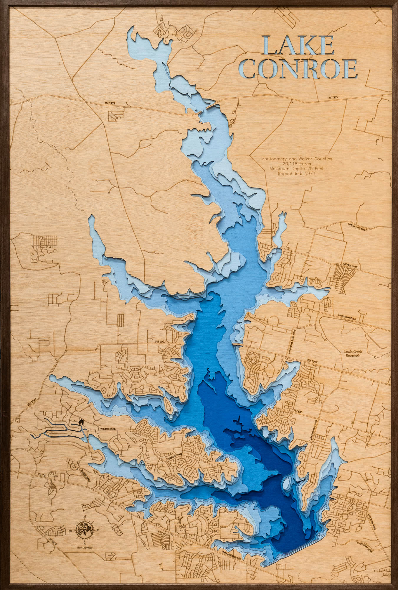
The Lake Conroe area description fromEast-Texas.com, places the lake west of Interstate 45 and north of Highway 105, with Conroe to the southeast, Montgomery to the southwest, and Willis near the eastern side. The lake stretches north toward the Sam Houston National Forest and includes a jagged shoreline with many coves and arms.
That shape matters. A windy day, a busy weekend, or a change in water level can make one part of the lake feel very different from another. A guide is not just choosing "Lake Conroe." He is choosing where on Lake Conroe your group has the best shot at a good day.
The lake is bigger than it looks from the road
East-Texas.com describes Lake Conroe as lying on the West Fork of the San Jacinto River just west of Interstate 45 off State Highway 105. It also notes that the lake is over 20 miles long, has roughly 150 miles of shoreline, and is bordered on the north by the Sam Houston National Forest.
For visitors, that means drive time and boat time both matter. The best place to fish may depend on where you meet, what the wind is doing, what species you want, and whether the group needs a comfortable pace.
Coves, open water, and timber fish differently
A map helps explain why Lake Conroe does not fish the same everywhere. Coves may offer protection or shoreline cover. Open water may matter for white bass or hybrids. Upper-lake timber and shallow areas can require more caution. Docks, brush, bridge areas, and points can all become part of the plan.
The right choice depends on the day. Wind, sun, rain, water level, boat traffic, and bait movement can all push the plan toward a different part of the lake.
What the map means for families
For a family trip, the map is about comfort as much as fishing. A shorter run, a calmer area, a safer wind angle, or a species that keeps kids engaged may matter more than chasing the most technical pattern on the lake.
Billy can talk through the meeting details, what part of the lake makes sense, and what fish are realistic for your date. That keeps the day simple for guests who just want to show up, fish, and enjoy Lake Conroe.
Use the map, then call the guide
A map is a good starting point. It shows the area, the towns, the main roads, and why the lake has so many different fishing situations. It does not tell you what the wind did last night, where the bait moved, or which species is worth your time today.
That is where Billy Mills Git-A-Guide helps. Use the map to understand the lake, then call Billy to plan the actual trip.
Frequently asked questions
Where is Lake Conroe?
Lake Conroe sits west of Interstate 45 near Conroe, Montgomery, Willis, and the Sam Houston National Forest north of Houston.
Why does the map matter for fishing?
The map shows why a guide matters: Lake Conroe has coves, long shorelines, open-water sections, roads, ramps, timber areas, and different neighborhoods around the lake.
Is every part of Lake Conroe the same?
No. The lower lake, upper lake, coves, bridge areas, and shoreline cover can fish differently depending on weather, water level, season, and boat traffic.
Use the map to get oriented.
Then call Billy to choose the right part of Lake Conroe for your group.
Related posts
Lake Conroe Fishing Pier: What to Know Before You Go
A practical guide to Lake Conroe fishing piers, public access, private marinas, shore-fishing plans, rules, and when a boat is the better fit.

Lake Conroe Fishing Report: What to Check Before You Go
A practical Lake Conroe fishing report guide covering lake level, weather, fish, safety, and how to plan a better day on the water.
Lake Conroe Depth Map: How to Read It Before Fishing
How to use a Lake Conroe depth map, understand contour lines, check the current lake level, and make a safer fishing plan.